Taino Bay Puerto Plata Port Map: Complete Cruise Port Guide
If your cruise itinerary includes Puerto Plata, Dominican Republic, the Taino Bay cruise port is one of the first places you will encounter after stepping off your ship. Rather than a simple docking area, Taino Bay features swimming pools, restaurants, bars, shopping, entertainment, and recreational attractions within the port complex.
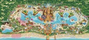
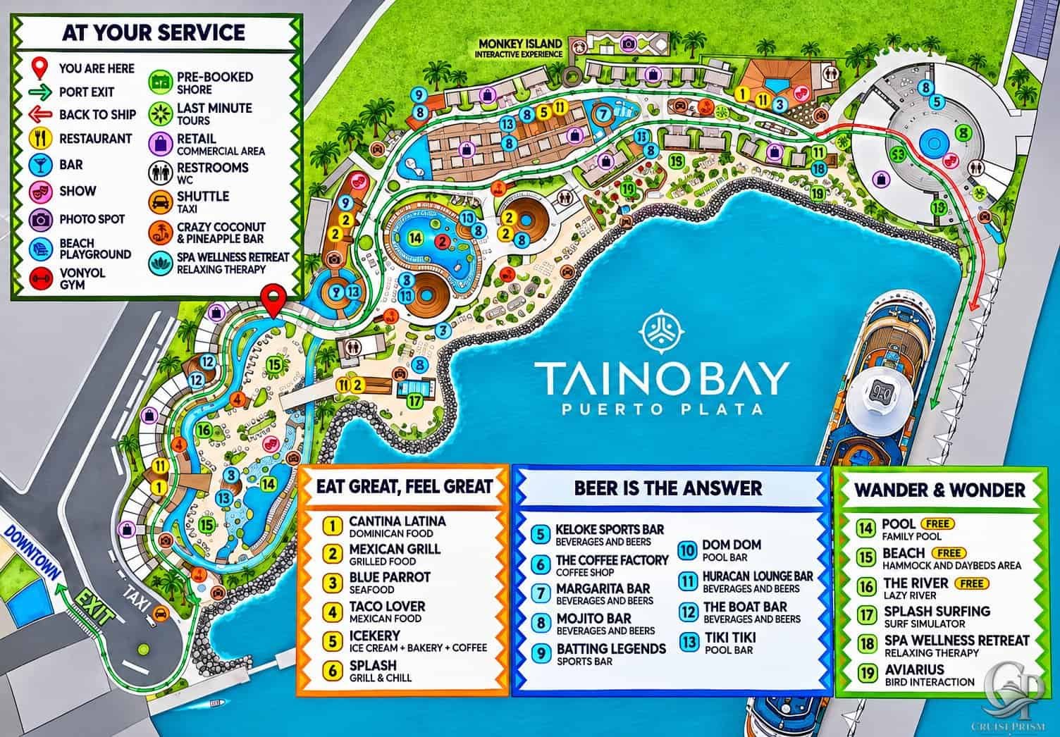
For cruise passengers planning their day ashore, understanding the layout can make a significant difference. The Taino Bay Puerto Plata port map featured in this guide identifies the main attractions, dining locations, swimming areas, transportation points, and routes leading back to the ship.
Whether you plan to spend your port day relaxing by the pool, exploring downtown Puerto Plata, or taking a shore excursion, this guide will help you navigate the terminal and decide where to go.
Taino Bay Puerto Plata Cruise Port Map

The official-style visitor map shown above provides an overview of Taino Bay’s facilities, including the waterfront promenade, swimming pools, restaurants, bars, shops, and entertainment areas.
The map uses numbered locations and color-coded symbols to help passengers identify different services.
Among the facilities identified are:
- Restaurants and casual dining establishments
- Bars and lounges
- Swimming pools and beach-style relaxation areas
- Retail shops and commercial areas
- Entertainment and interactive experiences
- Spa and wellness facilities
- Restrooms
- Taxi and shuttle transportation
- Pre-booked shore excursion meeting areas
- Last-minute tour services
- Designated photo locations
- Port exit and return-to-ship routes
One particularly useful feature is the directional system. Green arrows identify the route toward the port exit, while red arrows indicate the way back to the ship.
The map also marks a “You Are Here” location near the central portion of the complex.
Free Swimming Pools and Relaxation Areas at Taino Bay
One of the most attractive features of Taino Bay is that passengers can enjoy several recreational areas without necessarily leaving the cruise port.
The map specifically identifies three attractions as free.
14. Family Pool – Free
The Family Pool is one of the principal swimming areas within the port complex.
Located among the winding pathways and surrounding facilities, it provides an option for passengers who want to enjoy the Caribbean atmosphere without booking a separate excursion.
15. Beach – Free
The map identifies a beach-style relaxation area with hammocks and daybeds.
Although labeled “Beach,” the illustrated area is part of the port’s landscaped waterfront complex. The map does not establish that it is an open-ocean swimming beach.
For passengers primarily interested in lounging and relaxing, this area offers an alternative to spending the day sightseeing.
16. The River – Free
The River is identified as a lazy river, with its winding layout clearly visible on the map.
It curves through part of the port complex, passing landscaped areas and other recreational facilities.
This is another attraction specifically labeled free on the visitor map.
Important: The map confirms that the Family Pool, Beach, and River are free. It does not establish whether particular loungers, premium seating, or additional services have separate charges.
Other Attractions and Activities at Taino Bay
Beyond the three free recreational areas, the map identifies several additional activities.
17. Splash Surfing
Splash Surfing is listed as a surf simulator.
This attraction offers an alternative to traditional poolside relaxation for passengers interested in a more active experience.
The map does not specify pricing, age restrictions, operating hours, or participation requirements.
18. Spa Wellness Retreat
The Spa Wellness Retreat is described as offering relaxing therapy.
Passengers interested in spa treatments can use the map to locate this area within the port.
Individual treatment options and prices are not provided.
19. Aviarius
Aviarius is identified as a bird interaction attraction.
Its location is marked near the waterfront side of the complex, allowing visitors to identify where the experience is situated.
Monkey Island Interactive Experience
The upper portion of the map identifies Monkey Island as an interactive experience.
It is located toward the rear of the illustrated port complex, away from the main ship docking area.
The map confirms the attraction’s presence but does not provide admission prices or details about the experience.
Additional Entertainment
Other symbols identify:
- Shows and entertainment areas
- Designated photo spots
- Beach playground facilities
- Vonyol Gym
These attractions give passengers additional options beyond swimming and dining.
Restaurants at Taino Bay Puerto Plata
Taino Bay features several restaurants and casual dining locations, identified in the orange “Eat Great, Feel Great” section of the map.
The numbered dining establishments are:
- 1. Cantina Latina: Dominican food
- 2. Mexican Grill: Grilled food
- 3. Blue Parrot: Seafood
- 4. Taco Lover: Mexican food
- 5. Icekery: Ice cream, bakery, and coffee
- 6. Splash: Grill and Chill
Dominican Food at Cantina Latina
Cantina Latina is identified as serving Dominican food.
For visitors who want to explore local cuisine without traveling outside the port, this restaurant is worth locating on the map.
Mexican Grill and Taco Lover
Passengers interested in Mexican-inspired food have two establishments identified on the map.
Mexican Grill specializes in grilled food, while Taco Lover is categorized as Mexican food.
Seafood at Blue Parrot
Blue Parrot is identified as a seafood restaurant.
It provides another dining option for passengers who prefer a sit-down meal rather than casual snacks.
Coffee, Ice Cream, and Casual Food
Icekery offers ice cream, bakery items, and coffee, while Splash is described as a Grill and Chill establishment.
These locations may be particularly convenient for passengers spending several hours enjoying the port’s recreational facilities.
The map does not list restaurant menus, food prices, or whether any dining packages are available.
Bars and Drinks at Taino Bay
The blue “Beer Is the Answer” section identifies nine beverage establishments throughout the port complex.
These include:
- 5. Keloke Sports Bar: Beverages and beers
- 6. The Coffee Factory: Coffee shop
- 7. Margarita Bar: Beverages and beers
- 8. Mojito Bar: Beverages and beers
- 9. Batting Legends: Sports bar
- 10. Dom Dom: Pool bar
- 11. Huracan Lounge Bar: Beverages and beers
- 12. The Boat Bar: Beverages and beers
- 13. Tiki Tiki: Pool bar
Poolside Bars
Dom Dom and Tiki Tiki are both identified as pool bars.
Their locations are particularly useful for visitors who want to remain near the swimming and relaxation areas.
Sports Bars and Lounges
Keloke Sports Bar and Batting Legends are categorized as sports bars, while Huracan Lounge Bar offers another beverage-focused location.
The Margarita Bar and Mojito Bar provide additional options around the complex.
Coffee Options
The Coffee Factory is specifically identified as a coffee shop.
Together with Icekery, it gives passengers alternatives to alcoholic beverages.
The map does not include drink prices, opening hours, or beverage package information.
Shopping and Retail Areas
Shopping is another major component of the Taino Bay cruise port.
The map uses purple shopping-bag symbols to identify retail and commercial areas.
These are distributed throughout the complex, including locations near the main pedestrian pathways.
For passengers interested in souvenirs or browsing shops, the symbols provide a convenient way to identify shopping areas without searching the entire terminal.
The map does not identify individual store names, merchandise selections, or prices.
Getting From Taino Bay to Downtown Puerto Plata
One of the most useful features of the map is the clearly marked exit toward downtown Puerto Plata.
The exit is illustrated at the lower-left portion of the complex, where a road leads away from the port.
The map also identifies taxi and shuttle transportation services near this exit.
Finding the Port Exit
Passengers planning to explore Puerto Plata independently should follow the green directional arrows.
These lead through the complex toward the designated port exit.
The map distinguishes this route from the red arrows used for returning to the ship.
Taxi Transportation
A taxi symbol appears near the port exit.
This helps passengers identify the general transportation area when planning independent sightseeing.
Taxi prices are not included on this particular map, so travelers should confirm fares before arranging transportation.
Shore Excursions
The map identifies two different excursion-related services:
- Pre-booked shore excursions
- Last-minute tours
These are represented by separate symbols, making it easier to distinguish organized excursion services from general transportation.
Passengers with pre-booked excursions should follow the meeting instructions supplied by their tour operator or cruise line rather than relying exclusively on the map.
How to Return to Your Cruise Ship
Finding your way back to the ship is especially important when visiting a large cruise terminal with numerous attractions.
The Taino Bay map makes the return route easy to identify through red arrows labeled “Back to Ship.”
The ship docking area appears along the right side of the illustration.
Passengers returning from downtown Puerto Plata or the port’s recreational areas can use these arrows to navigate toward the pier.
Before leaving the ship, always confirm the scheduled all-aboard time in your cruise line’s daily program or app.
The port map does not provide ship departure times, docking assignments, or individual cruise schedules.
Is Taino Bay Worth Exploring Without a Shore Excursion?
For passengers who prefer a relaxed port day, Taino Bay offers several reasons to remain within the cruise terminal.
The combination of free swimming facilities, restaurants, bars, shopping, and entertainment means visitors have multiple options without arranging transportation into the city.
Some of the main advantages include:
- Three recreational areas explicitly marked free
- Several dining options within the terminal
- Numerous bars and coffee establishments
- Shopping and entertainment facilities
- Clearly marked walking routes
- Access to taxis and organized tours
- A designated route back to the cruise ship
However, passengers interested in historical attractions, local neighborhoods, or destinations beyond the terminal will need to plan additional sightseeing.
Taino Bay is a cruise port complex, not a substitute for exploring the entire Puerto Plata region.
Tips for Visiting Taino Bay on a Cruise
A little planning can help passengers make better use of their time in port.
- Save the port map: Keep a copy on your phone so you can locate restaurants, pools, and transportation services.
- Identify the free attractions: The Family Pool, Beach, and River are specifically marked free.
- Locate the port exit: Follow the green arrows when heading toward downtown Puerto Plata.
- Check excursion meeting points: Pre-booked tours and last-minute tours have different symbols.
- Confirm additional charges: The map does not provide pricing for restaurants, drinks, spa treatments, or interactive attractions.
- Allow time to return: Follow the red arrows toward the ship and observe your cruise line’s all-aboard time.
- Check current availability: Individual businesses and attractions may change their hours or operations.
Frequently Asked Questions About Taino Bay Puerto Plata
Is Taino Bay a cruise port in Puerto Plata?
Yes. Taino Bay is a cruise port complex in Puerto Plata, Dominican Republic, with recreational facilities, dining, shopping, entertainment, and access to transportation.
Does Taino Bay have free swimming pools?
The visitor map identifies the Family Pool as free. It also marks the Beach relaxation area and The River lazy river as free.
Is the Taino Bay lazy river free?
Yes. The River, identified as attraction number 16, is explicitly labeled free on the map.
Are there restaurants inside Taino Bay?
Yes. The map identifies six dining establishments: Cantina Latina, Mexican Grill, Blue Parrot, Taco Lover, Icekery, and Splash.
Does Taino Bay have bars?
Yes. The map lists nine beverage locations, including pool bars, sports bars, a coffee shop, and other bars.
Can you walk around Taino Bay without booking an excursion?
The map shows a network of pedestrian pathways connecting the port’s recreational, dining, shopping, and entertainment areas. Visitors can use these pathways to explore the complex.
Where do you get a taxi at Taino Bay?
The map identifies a taxi and shuttle area near the port exit, on the downtown-facing side of the complex.
How do you get back to the cruise ship?
Follow the red arrows marked “Back to Ship.” These indicate the return direction toward the docking area.
Does Taino Bay have a beach?
The map identifies a free Beach area with hammocks and daybeds. However, it does not establish that this is a natural ocean-swimming beach.
Is Monkey Island located inside Taino Bay?
Yes. The map identifies Monkey Island Interactive Experience within the illustrated port complex.
Is everything at Taino Bay free?
No. Although the Family Pool, Beach, and River are explicitly marked free, the map does not indicate that all restaurants, bars, shops, or attractions are complimentary.
Can you visit downtown Puerto Plata from Taino Bay?
Yes. The map identifies a port exit toward downtown Puerto Plata, along with taxi and shuttle transportation services.
Conclusion
The Taino Bay Puerto Plata cruise port offers considerably more than a place for cruise ships to dock. Its combination of swimming pools, a lazy river, restaurants, bars, shopping, and entertainment gives passengers several ways to spend their time ashore.
The port map is particularly helpful because it identifies the three free recreational areas, dining establishments, transportation points, and directional routes throughout the complex.
For passengers planning to remain at the terminal, the map makes it easier to locate attractions and organize a relaxing day. For those heading into Puerto Plata, it provides a useful starting point for finding the exit and transportation services.
Whether you are visiting Puerto Plata for the first time or returning on another Caribbean cruise, keeping this Taino Bay port map available can help you make the most of your time ashore.